Victoria is awash
Flood water is causing havoc, breaking riverbanks – and hearts – on its way to the ocean via our rivers.
Brown water can be seen fanning way out into Port Phillip Bay from creeks and rivers. Perhaps this is a timely moment to consider the immense power of water and its immense impact on our lives.
Flood mitigation in the Yarra River, the Maribyrnong and various creeks feeding into the Yarra estuary is not new. Historic images and public records reveal that floods were a critical concern from the early days in 19th-century Melbourne, threatening lives, livelihoods, property and trade.
Prior to colonisation, for the Indigenous people, the threat of flooding was likely to have been less of a concern. Perhaps the seasonal inundation which naturally flushed the swamp and lower estuary actually improved its capacity and the supply of food.
Melbourne Maritime Heritage Network (MMHN) encourages all Docklanders to subscribe to the free Melbourne-based online news source The Conversation. An article on the floods ( October 14, 2022) reported that management of Yarra flooding mitigation has been happening for a very long time.
Historian Margaret Cook writes that although widespread floods in Victoria are uncommon, Victoria tends to experience “flash floods” because the stormwater drains in cities and towns can be overwhelmed by sudden downpours. Docklanders may be familiar with the lake in the Royal Botanic Gardens but may not be aware that it is the remnant of Yarra billabongs which swelled into existence during floods.
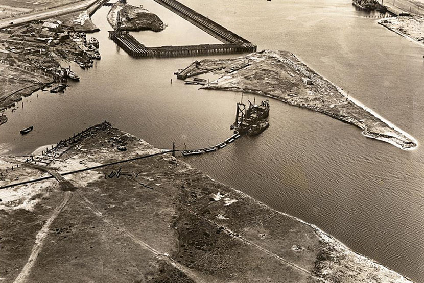
Docklanders will also be familiar with the work of Sir John Coode, the engineer commissioned by the state government to design Victoria Port (now known as Victoria Harbour), crucial maritime infrastructure (wharves) greatly increasing its capacity. This investment enabled Victoria to thrive and prosper through maritime trade.
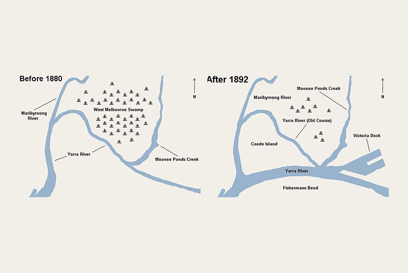
Perhaps less well known is that the ambitious Coode works were also designed to reduce the impact of dramatic disruptive flash-flooding of the Yarra River as it made its way to Port Phillip Bay.
In this sense, flood mitigation played a part in the creation of today’s Docklands Precinct. The Coode works changed the course of the Yarra River and deepened it. This lessened the adverse impact of flooding which periodically inundated and disrupted much of Melbourne in the late 19th century and early 20th century. The new, wide channel in the Yarra Estuary also improved cargo ship access to Docklands and is used to this day.
Pollution flush
The pattern of natural inundation which benefitted the swamps associated with the Yarra River estuary as it snaked its way to Port Phillip Bay have long gone. Docklanders are spared disruption today.
However, Docklands’ waterways now experience an ugly “modern inundation” of sorts. A by-product of the flooding in creeks and rivers upstream inevitably causes a significant increase in the volume of water-borne litter.
Parks Victoria has the task of trapping as much as it can – “at the end of the line”. Vast amounts of rubbish float past Docklands under the Bolte and the Westgate bridges and out to Port Phillip Bay.
Central Pier saga
As the tide ebbs and flows up the Yarra estuary and into in Victoria Harbour each day it hastens the degeneration of the Docklands Precinct’s iconic Central Pier. The sorry saga of the heritage-listed pier is drawing to a close.
Early in October 2022 Development Victoria (DV) applied to Heritage Victoria (HV) for a permit to demolish the pier, stating, “engineering advice has confirmed that the condition of the pier continues to deteriorate and no loading of the pier or access onto or below the deck is advisable under current conditions”.
DV proposed that work be completed in two stages: Stage One (design and investigation) and Stage Two (demolition) “including, but not limited to, demolition of Central Pier including Sheds 9 and 14, the decking and piers to the seabed”.
See https://www.tenders.vic.gov.au/tender/view?id=241414
MMHN has no doubt that HV heritage experts agonised over this decision. We recommend that Docklanders read the heritage Statement of Significance for Victoria Dock (and Central Pier).
See http://vhd.heritage.vic.gov.au/search/nattrust_result_detail/3705
Public safety obviously trumps heritage preservation. Docklanders may also check Demolition Permit details for Central Pier.
For more information: https://www.heritage.vic.gov.au/permits-and-approvals/recent-permit-decisions
Absence of a Victoria Harbour plan – the heart of Docklands
It is hard to comprehend why such a plan does not exist already – surely this is an oversight?
MMHN would like to draw your attention to the really important wording in the HV Permit which refers to a plan encompassing the whole of Victoria Dock, not just Central Pier and the adjacent spaces along Harbour Esplanade …
“Heritage Victoria recognises that a well-considered future plan is required for Victoria Dock and acknowledges that this will take some time to develop. The risk of collapse is such that Development Victoria has not lodged a proposal to rebuild or redevelop the site as part of this permit.”
Development Victoria has publicly declared their intention to engage on the future of Victoria Dock, and community engagement has commenced via engage.vic.gov.au/central-pier
Your opportunity
MMHN encourages all Docklanders to participate in this DV community consultation. This is an opportunity to tell what DV precisely what Docklanders expect DV to provide to compensate the community for the loss of Central Pier – a much-loved and significant heritage infrastructure asset in the heart of the Docklands Precinct.
MMHN has long anticipated this heritage loss and has proposed an appropriate ‘replacement’ structure to compensate for this loss. See https://mmhn.org.au/wp-content/uploads/2021/09/MMHN-Opportunity-1-Maritime-Centre-Sept-2021.pdf •

Police search after motorbike stolen from Docklands


 Download the Latest Edition