
Swamped for views

By Ashley Smith - Royal Historical Society of Victoria
Once upon a time, the northern part of the Docklands was a lagoon surrounded by a marshy swamp.
Up until the mid-20th century, the area between North Melbourne and the Maribyrnong River was home to Batman’s Swamp also known as West Melbourne Swamp.
This view across the city blocks toward the swamp was taken by photographer John Noone in 1869 from the tower of Dr Thomas Fitzgerald’s house “Rostella” in Lonsdale St near what is now the County Court (where only the iron gates remain). The photograph was one of eight commissioned for a presentation created for visiting British Naval Officers.
While the large pool of water is prominent in the background, the foreground also gives us a glimpse of West Melbourne at the time. In the foreground is William St, as well as the recently closed Metropolitan Hotel (on the corner of Little Lonsdale St) and the West Melbourne Common School and Literary Institute (at the bottom of the image).
Before European settlement, the swamp (which received water from Moonee Ponds Creek before it filtered into the Yarra) was an important meeting site and a resource for the indigenous peoples of Victoria. The Woi Wurrung would harvest shellfish and hunted game in the area.
Europeans first encountered the lagoon during the 1803 expedition of the Yarra by surveyor-general Charles Grimes. James Fleming, who assisted Grimes, wrote in his journal that, as they climbed Batman’s Hill, they spotted a lagoon “in a large swamp between two rivers; fine grass, fit to mow; not a bush in it”, with black soil “six to 10 inches deep”.
They wouldn’t be the last Europeans to admire the ecosystem of this region. In John Batman’s initial visit in 1835, he noted in his journal the sight of “1000 quails flying at one time, quite a crowd”.
Writing in the Victorian Historical Magazine (VHM) in 1912, George Gordon Macrae reported that when he hunted with his father as a child in the 1840s, the swamp resembled “a real lake, intensely blue, nearly oval, and full of the clearest salt water …” surrounded by pigface flowers. It’s likely the blue colour refers to the blue clay that rested at the lagoon’s bottom.
Another local from the early settlement, Albert Mattingley (writing in the VHM in 1916) noted the fauna included birdlife such as swans, pelicans, and sea gulls with eels and frogs inhabiting the water.
However, the region didn’t stay pristine for long. Grazing animals consumed the plants, while abattoirs and noxious industries were built along the Yarra, turning the swamp into a dumping ground for their waste. The consequences would be apparent in the decades that followed.
A medical professional going by the alias “Medicus” complained to The Argus in 1866 (February 17) that the polluted swamp had become a malaria risk, and the stench in dry season was “sufficient enough to poison a whole neighbourhood”. They were especially concerned with the effects of the polluted swamp, noting that locals who lived closer to the area were more likely to have catarrh (or excessive mucus in nose and throat) become “the most serious forms of intermittent fever (ague), with diseases of the liver and spleen”.
In 1872 and 1873 a Royal Commission (known as the Low Lands Commission) was ordered to investigate the low lying lands south and west of Melbourne, including the swamp. Its main intent was to find “the best and most economical application of said lands for commercial and public purposes”. Eventually, noting the expensive cost to convert the land for residences, they concluded that the swamp would “be enclosed and drained, so as to be made suitable for purposes of recreation as a park or for cultivation or grazing.”
The first works to drain the swamp started in 1877 with hopes of converting the lowlands for grazing and the higher portions for market gardens (Argus, June 4). The Herald (October 27) reported that the scheme would involve encircling a three-and-a-half-mile portion of the swamp with a canal, with the excavated dirt forming an embankment. All water would flow back into the Moonee Ponds Creek. A pumping station was built at Brown’s Hill, near Kensington, capable of pumping out 6000 gallons of water a minute.
The scheme was completed by late 1878, with The Argus (December 23) reporting that the drained land was “dry” and “ready for successful and profitable cultivation”. However, the market gardens plan was abandoned, with The Argus (August 2, 1883) suspecting it was because of “the sourness of the ground”, likely referring to the salt still imbedded in the soil.
It wouldn’t be the last works done on the area, and in the decades that followed the swamp dwindled away. The Coode Canal, which re-worked the Yarra’s course, reduced the risk of flood into the swamp during times of heavy rain. Further drainage and filling works (especially under the supervision of contractor Michael Walsh in the late 1900s), and construction of docks and industrial works further eroded the swamp, until there were virtually little to no traces of it left by the 1950s.
The once vibrant swamp is now paved over with the old wholesale fruit and flower markets, the railways linking to North Melbourne and Southern Cross, the docks and container storage and various industries. It is a sad reminder that the views like the one taken more than 150 years ago are no match for progress •
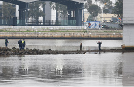
Pam the Bird suspect arrested after Bolte Bridge standoff
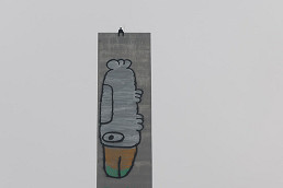
Police in standoff with Bolte Bridge graffiti trespasser

 Download the Latest Edition