
Evidence of Melbourne’s maritime heritage is everywhere in Docklands

Acknowledging the immense significance of the area in generating great prosperity for Victoria should be an opportunity for pride and celebration.
However, one element of the Docklands precinct maritime heritage which is seldom acknowledged is Dudley Flats, located directly to the west and known as the area’s dark underbelly. But the story of Dudley Flats is inextricably linked with Melbourne’s port heritage and the evolution of today’s Docklands precinct.
The story is complex. Think waterways, flooding, swamps and lagoons. Think commercial pressures emanating from the burgeoning port city to dramatically reshape both the land and the waterways. Think coal power and steam power and cargo on land and at sea. Think extraordinary port infrastructure investment by government – Coode Canal, Railway Coal Canal, and the vast, world-renowned Victoria Harbour. The evolving story of Dudley Flats is integral to all of these.
In the 19th century, Dudley Flats was an unstable, fluid site spreading over both banks of the Moonee Ponds Creek. At various times it was a saltwater lagoon or a swamp. It was commonly known as Batman’s Swamp (or in earlier times the Blue Lake) and it conveniently absorbed the foul effluent generated by the industrious population of the booming city that sat on the Birrarung/Yarra River to the east.

Image: Map of Coode Island and the swamps west of Melbourne, The Royal Historical Society of Victoria.
As is the case today in booming cities, while many people in Melbourne prospered, inevitably some people were left behind and became destitute. In the 1920s, Dudley Flats began to attract the homeless, and when the Depression hit in 1931, many more impoverished people gravitated to the unregulated Dudley Flats site. There they lived free of charge in squalid hovels known as “humpies”, made from scavenged materials washing up on the riverbank or dumped in swampy areas west of the city.
Materials such as timber, corrugated iron or even hessian sacking were commonly used. With a cruel sense of irony, some referred to these hovels as “Dudley Mansions”. By 1935, more than 60 humpies had been erected along the waterways and around the rubbish tip to the west of the city.
Dudley Flats had its own precincts that authorities identified as “Dudley Flats Proper”, “Bachelor Quarters” and “Happy Valley”. Life in these slums was notoriously tough and often violent. Although very near to the CBD, they were, to an extent, beyond the law.
Over time, the movement to reclaim this “wasteland” and create actual real estate with value close to the west of the city gained traction. This may be attributed to advocacy from the commercially savvy government, interest from the private sector, or the concerns of Melbourne’s more humane citizens.
Yet, despite municipal plans to improve social conditions, many attempts to demolish humpies, and regular police action, efforts to remove these people generally failed. Occupation continued up until the Second World War (see image).
Why did the complete clearance of Dudley Flats take so long? It’s hard to be definitive but the fact remains that Dudley Flats fringe dwellers consistently resisted pressure to relocate to mainstream charitable accommodation. Some actually made a living scavenging (or, in modern parlance, recycling useful rubbish). Later, casual work opportunities arose in the nearby port or railways.
But there were other unhelpful factors. Bureaucratic demarcations and disputes between the various government agencies hampered progress. The Railways Department, Melbourne City Council, the Melbourne Harbour Trust, the Board of Works, and the Lands Department all refused to claim responsibility for improving the slum site. The commercial benefit of collaborating to improve the Dudley Flats site seemed lost on the various agencies.
It comes as no surprise, given its proximity to the port and the immense importance of maritime trade, that the Harbour Trust was eventually given authority over Dudley Flats. This authority was termed “permissive occupancy”, indicating that the site was reserved, awaiting eventual port developments. The obvious synergy between port infrastructure, railway infrastructure, and proximity to the city became apparent.
The evolution of the site west of Docklands, from the intermittent wetlands of Batman’s Swamp to the stable, habitable land known as Dudley Flats, occurred in tandem with the expansion of Melbourne as a maritime port city. In response, change propelled by social and commercial forces came to the land and waterways of the Docklands precinct.
Today the Docklands precinct reveals evidence of railway and port infrastructure, but archives best tell the story of Dudley Flats. •
Main Image: The front view of a Dudley Mansion, West Melbourne, ca. 1935, F. Oswald Barnett, State Library Victoria H2001.291/68
Related Articles
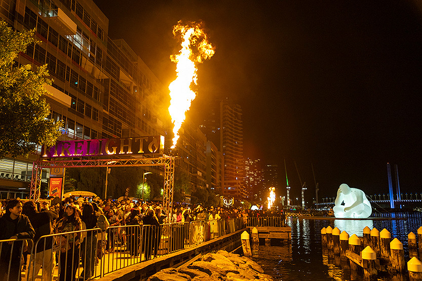
Docklands: Firelight returns, and the harbour takes centre stage
Melbourne is into the coldest stretch of the year, which is precisely when Docklands does its best work – turning Victoria Harbour into a stage.
Read More
Schools in Docklands
After a regrettably long delay, we are delighted to welcome news of a new campus for Docklands Primary School. But we say, this is not enough! Now is the time to ramp up pressure on the state government for a Docklands Secondary School.
Read More
State agencies continue to fall short – Docklands deserves better
Three State Government agencies – Parks Victoria (PV), Melbourne Water (MW), and Development Victoria (DV) – continue to fall short in their obligations to the Docklands community.
Read More
From one café client to 60 brands: The growth of Born Social
Tram bridge to E-Gate still possible despite West Gate Tunnel fears

 Download the Latest Edition