Docklands at risk from future flooding

Buildings across Docklands could be vulnerable to water damage and flooding if current sea level rise predictions are accurate.
Since 2008, the State Government has required authorities to plan for a sea level rise of no less than 0.8 metres by 2100.
Accordingly, all new buildings in areas such as Docklands, which is considered to be within the sea level rise zone, are required to have a floor level 2.4 metres higher than the average sea level.
However, many building in Docklands were built before the guidelines were introduced and, while some of them won’t be affected by the predicted sea level rise, others could be facing significant problems.
Docklands News took measurements around Docklands in March and calculated how high above the water level buildings’ entrances were located.
Despite the majority of NewQuay being constructed pre-2008, Docklands News found that the precinct’s residential towers met the new flood level requirements with floor levels approximately 2.9 metres above water level.
Even wharf’s edge retailers, such as the ice cream and fish and chip outlets, met the flood level requirements, sitting around 2.4 metres off the water.
Unfortunately the same can’t be said for waterfront restaurants Berth and Cargo, which, at 1.6 metres above the water, would be flooded if sea level rise predictions are reached.
Harbour Esplanade is also lower than the required flood level, sitting at 1.4 metres, according to Places Victoria’s Harbour Esplanade masterplan.
However, the urban renewal authority plans to reinstate 2.6 metre high raised decks at sections to allow for development along parts of the esplanade.
Many buildings opposite the Harbour Esplanade waterfront, such as those in the Digital Harbour precinct could visually be perceived as sitting at the same 1.4 metre floor level.
But Digital Harbour director David Napier told Docklands News this was not the case.
Mr Napier said the Life.lab building on Harbour Esplanade had a floor level of 3.1 metres (above water level) and the Customs building next door had a floor level of 3 metres.
In Victoria Harbour, buildings along the eastern end of Victoria Harbour Promenade are estimated to sit around 2.3 metres above water level, almost reaching the flood level requirement.
In contrast, newer buildings at the western end of the promenade well and truly clear the 2.4 metre requirement. The Library at the Dock sits around 2.9 metres above water level.
The water-side of ANZ is also safe, with the building sitting at approximately 2.6 metres above the water level.
But on the other side of the river at Yarra’s Edge things might not be so rosy if sea levels rise.
Older buildings along Yarra’s Edge could be at risk as they are estimated to have a floor level of 1.9 metres above water.
But Mirvac’s newest building at Yarra’s Edge, Arra and Yarra Point, will be safe – sitting at 2.4 metres above water level.
A Mirvac spokesperson confirmed all Yarra’s Edge towers complied with Melbourne Water’s flood level requirements current at the time of building permit applications.
Despite some Docklands buildings sitting below the 2.4 flood level requirement, outlined in both the Victorian Coastal Strategy 2014, and the Victorian State Planning Policy Framework, most appear to meet the requirement.
And, as Melbourne Water spokesperson Nicolas McGay explained, planning requirements recognise the need for an active interface with the street, which may require a lower entrance.
Melbourne Water is the flood plain management authority for Port Phillip and Westernport and gives advice on development proposals in Docklands.
According to Mr McGay, while entrances to buildings may be lower than the required floor level, the floor level must sit at 2.4 metres above water level at points of the building that incorporate electrical functions such as lifts.
Related Articles

Immersive Melbourne festival to return in 2024
Now or Never, the new festival celebrating art, sound, and technology, which had a significant presence in Docklands during its in inaugural year in 2023, will return to Melbourne this winter.
Read More
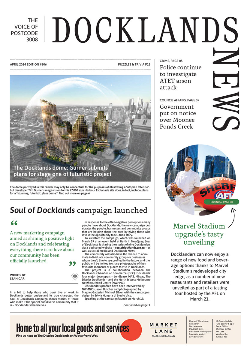
Soul of Docklands campaign launched
A new marketing campaign aimed at shining a positive light on Docklands and celebrating everything there is to love about our community has been officially launched.
Read More
New Docklands Primary campus opens at the District
A brand-new learning space campus for Docklands Primary School has opened at The District Docklands shopping centre, providing an environment for students to thrive.
Read More
New park to revitalise historic maritime precinct in Docklands

New plans for Australia’s largest built-to-rent development in Docklands
 Download the Latest Edition